The New York State Library has primary sources (maps, journals, letters, newspapers) and secondary sources (books, magazine articles) that can help teachers.
In September 1609 Henry Hudson sailed up what we now know as the Hudson River. The knowledge he gained from that trip encouraged the Dutch to establish trading posts and settlements.
Maps
Map makers used the information gathered by Hudson and the men who sailed to North America before and after him.
As map makers gathered more and more information, the maps they drew became more and more detailed.
The New York State Library has maps and atlases dating from the 16th century to the present. Some maps are linked to records in the State Library's online catalog.
You can use QUICK SEARCH, POWER SEARCH or CALL NO. BROWSE to search the catalog by author, title, author and title, call number, date(s).
NOTE: On some maps, the Hudson River is called the Noordt Rivier.
A larger, electronic, hand-colored copy of each of the maps listed below is available by clicking on the map, or on the link in the catalog record in the New York State Library's online catalog. The maps are in PDF format, allowing you to use the magnifying glass icon to zoom into the land on either side of the Hudson River. Using the camera icon and the printer icon, you can print out a section of the map.
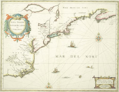
This map shows the Zuydt (South/Delaware), Noordt (North/Hudson) and Versche (Fresh/Connecticut) rivers; Fort Orangen; area occupied by the Mahicans and Maquaas; Manhattan and [Long Island]
To view a larger, hand-colored copy of this map, click on it, or go to the New York State Library's online catalog and do a title, author or call number search.
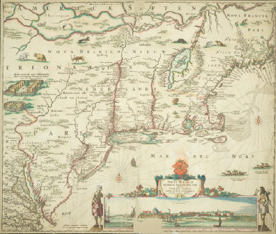
This map shows the Zuydt (South/Delaware), Noordt (North/Hudson) and Versche (Fresh/Connecticut) rivers; Fort Orangie PLUS Colonye (Colonie) and Rensselaerswyck, Kinder hoeck (Kinderhook), Kats Kill (Catskill), Wappinges (Wappingers); Mahicans and Mackwaas PLUS pictures of Indian castles; Manhattan PLUS image of the fort and t Lange Eylandt (Long Island) PLUS images of native wildlife (deer, bear, beaver, turkey)
To view a larger, hand-colored copy of this map, click on it, or go to the New York State Library's online catalog and do a title, author or call number search.
To view a larger, hand-colored copy of this map, click on it, or go to the New York State Library's online catalog and do a title, author or call number search.
While the three maps listed above show large areas of New York State, the following two maps focus on a small portion of the state, specifically Rensselaer and Albany counties, the counties that originally were part of the Rensselaerwyck (Rensselaerswijck) Manor.
In 1630 Kiliean van Rensselaer signed an agreement with the West India Company to establish a colony in the province of New Netherland. Van Rensselaer was obligated to settle 50 colonists on land at his own expense. In return, the property was his to hold as long as he lived and dispose of as he wanted by his last will and testament. The property, lying on both sides of the Hudson River that now is known as the Albany and Rensselaer counties, was named the Rensselaerwyck Manor and Van Rensselaer was the patroon (lord of the manor).
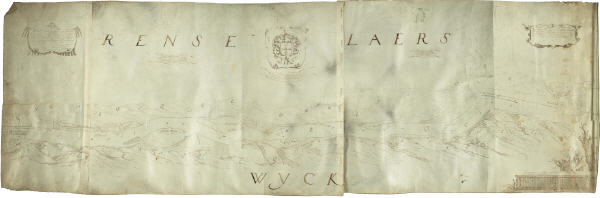
This map was prepared for Kiliean Van Rensselaer. It shows (1) Fort Orange, (2) three Mohican sites: Monemin's Castle on present-day Peebles Island, Unuwa
t's Castle, which may have been on the Lansingburgh-Troy line beside the river, as many artifacts were found there (today, it's the site of a Greek Orthodox Church), and on the east side of the river, opposite present Menands, was a location titled Dickop's House, and (3) and four prospective farms: DeLaet's Burg, southeast of Fort Orange on the eastern side of the Hudson; Godyns Burg, south of Fort Orange on the western side of the river, and Renselaers Burg and Welys Burg on the north end of Castle Island. (Welys Burg was named for Van Rensselaer's second wife, Anna van Wely.)
If you zoom in to the full-size map you will see the farmhouses and the Indian castles/homes.
To view a larger, hand-colored copy of this map, click on it, or go to the New York State Library's online catalog and do a title, author or call number search.
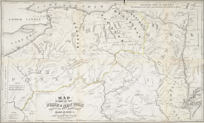
A map drawn in 1767 shows the locations of the lands owned by the people who were living on Kiliaen Van Rensselaer's manor at that time and includes their names.
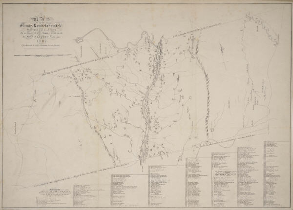
A Map of the Manor Renselaerwick surveyed and laid down by a scale of 100 chains to an inch by Jno. R. Bleeker, surveyor ; from the original in possession of Genl. Stephen Van Renselaer [sic] ; copied from the original by D. Vaughan (This is a reprint of the original and was published in the 1800s.)
This map shows mountains, streams, names of landowners and where their farms were located.